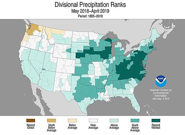
The contiguous United States recently completed its wettest May to April period on record, according to the National Oceanic and Atmospheric Administration’s National Centers for Environmental Information (NOAA/NCEI). From May 2018 to April 2019, an average of 36.20 inches of precipitation fell across the Lower 48 states, 6.25 inches above the 20th century mean. In fact, it was the nation’s wettest 12-month period on record, regardless of which months are chosen.
One real-world impact from the nation’s wettest 12-month period has been a painfully slow 2019 planting pace for many major U.S. row crops. Soils in prime agricultural regions of the Plains and Midwest, which initially became saturated last autumn and were periodically blanketed with heavy snow during the winter of 2018-19, have remained wet into the 2019 planting season amid relentless spring rainfall. Exceptionally wet spring conditions are especially detrimental for planting operations for a variety of reasons, including concerns about soil compaction during seeding operations and the inability of saturated soils to support heavy farm equipment.
As a result, U.S. corn planting failed to reach the halfway mark by May 19 for the first time on record. Only 49 percent of the intended U.S. corn acreage had been sown by May 19, 2019, compared to the previous record low of 50 percent on May 19, 1995. Similarly, just 19 percent of the U.S. soybeans had been sown by May 19, 2019, the least amount planted on that date since 1996. By June 2, 2019, both corn and soybean planting were proceeding at a record slow pace, with just 67 percent of the corn and 39 percent of the soybeans sown by that date. Previous June 2 planting records of 77 and 40 percent, respectively, had been set in 1995.
Wetness-related impacts have extended to the nation’s waterways, with record flooding developing as early as mid-March in portions of the Missouri Valley States of Iowa, Nebraska, and South Dakota. Later, a record crest was set on May 2 along the Mississippi River at Rock Island, Illinois, edging a July 1993, standard. Farther downstream, the Mississippi River at Burlington, Iowa, remained at major flood stage or above on 62 consecutive days from March 16 to May 16, 2019, shattering the June-August 1993 mark of 41 days. More recently, record flooding has affected the Arkansas River Basin and has returned to the middle Mississippi Valley.
The extensive flooding has slowed or halted barge traffic over large segments of the inland waterway in the Midwest. For example, barge traffic on the Mississippi near Saint Louis, where large volumes of Corn Belt corn and soybeans normally transit starting in mid-March has seen little to no increase thus far this spring. Volumes of corn and soybeans passing Saint Louis are just half levels seen in recent years.
The summer (June-August 2019) outlook from the Climate Prediction Center of the National Weather Service suggests the likely continuation of wetter-than-normal weather across much of the country, including large sections of the Plains and Midwest. Meanwhile, cooler-than-normal summer conditions can be expected across the Plains and upper Midwest. A cool wet summer and delayed planting could reduce yield potential due to a shortened growing season and increased risk of corn and soybeans not reaching full maturity prior to the first autumn freeze.


